LFSR, short for "Laboratório de Fotogrametria e Sensoriamento Remoto" (Laboratory of Photogrammetry and Remote Sensing) is an official research group affiliated with the Rio de Janeiro State University (Universidade do Estado do Rio de Janeiro - UERJ). Established in 2002, the lab gained recognition with the launch of the e-foto project, an award-winning free photogrammetric software kit that was the first of its kind worldwide. Since its inception, LFSR has expanded its research scope to encompass cutting-edge studies in Photogrammetry and Remote Sensing, utilizing images and data from remote sensors to extract both metric and thematic information about our surroundings. Its applications span diverse fields, including conventional cartography, architecture, industry, and health sciences.
The lab is registered both as a certified Research Group (by the Brazilian National Council of Research) and as a Unit of Technological Development by InovUERJ, the university's innovation department. These credentials highlight the lab's potential for collaboration among academia, government institutions, NGOs, and the industry.
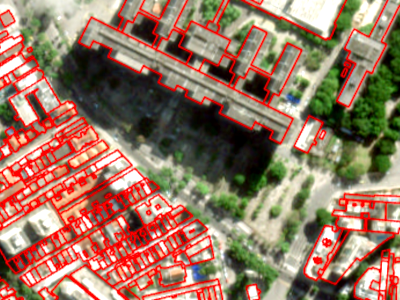
The lab focuses on three primary research areas. Firstly, it specializes in software development for Photogrammetry and Remote Sensing, with a particular emphasis on free and open-source software solutions. Secondly, it applies these techniques for Earth observation and Geoinformation extraction. Lastly, LFSR strives to drive innovation in the utilization of Photogrammetry and Remote Sensing at short distances.
Situated at UERJ's main campus in Maracanã, Rio de Janeiro, the lab occupies the João Lyra Filho pavilion (rooms 4044F and 4040F). It boasts dedicated spaces for development, research, a classroom, and other facilities catering to students and researchers. While officially associated with the Department of Cartographic Engineering within the School of Engineering, the lab collaborates with researchers and students from various units within the university, as well as partners both locally and internationally.
This website provides a brief overview of the lab. For more comprehensive information about our research and opportunities for engagement, it is recommended to follow LFSR on social media or reach out to us directly through messaging.
About our logo: it features four squares that can be interpreted in two ways. Firstly, they can represent a sequence of aerial or satellite images with stereoscopic overlap, symbolizing the field of photogrammetry. Secondly, they can be seen as the four bands (RGB and panchromatic) of a single aerial or satellite image, representing the data captured by remote sensing. The logo was conceptualized by professors Coelho and Irving, with valuable input from Michelle Costa da Silva.