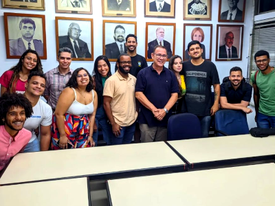
Our laboratory collaborates with a diverse group of researchers from both UERJ and partner institutions. It provides valuable opportunities for postgraduate and undergraduate students who work under the guidance of one or more researchers associated with the laboratory.
Although our laboratory is formally based at the Department of Cartographic Engineering at UERJ, which involves specific administrative and organizational responsibilities for those directly affiliated with the department, LFSR operates within an extensive network of researchers who actively collaborate with us on various projects and development initiatives. Below is a comprehensive list of individuals currently involved with our laboratory.
Researchers directly affiliated with the Department of Cartographic Engineering at UERJ:
 |
Luiz Carlos Teixeira Coelho Filho (also known as Luis Carlos Teixeira Coelho), DSc
Research Group Leader, Technological Development Unit Leader
Adjunct Professor
Rio de Janeiro State University - School of Engineering - Department of Cartographic Engineering
Pereira Passos Municipal Institute of Urban Planning - Researcher
Lines of research: Software Development in Photogrammetry and Remote Sensing, Photogrammetry and Remote Sensing for Earth Observation, Close-Range Photogrammetry and applications
      
|
 |
Jorge Luís Nunes e Silva Brito, PhD
Research Group Vice-Leader, Technological Development Unit Vice-Leader
Full Professor
Rio de Janeiro State University - School of Engineering - Department of Cartographic Engineering
Lines of research: Software Development in Photogrammetry and Remote Sensing, Photogrammetry and Remote Sensing for Earth Observation, Close-Range Photogrammetry and applications
|
 |
Luiz Henrique Guimarães Castiglione, DSc
Full Professor
Rio de Janeiro State University - School of Engineering - Department of Cartographic Engineering
Line of research: Photogrammetry and Remote Sensing for Earth Observation
|
 |
Sonia Maria Lima Silva, DSc
Adjunct Professor
Rio de Janeiro State University - School of Engineering - Department of Cartographic Engineering
Line of research: Photogrammetry and Remote Sensing for Earth Observation
|
 |
Samir de Souza Oliveira Alves, DSc
Adjunct Professor
Rio de Janeiro State University - School of Engineering - Department of Cartographic Engineering
Line of research: Close-Range Photogrammetry and applications
|
 |
João Victor Pacheco Gomes, DSc
Adjunct Professor
Coordinator of the Extension Program: "Remote Sensing practices aimed at continuous formation"
Rio de Janeiro State University - School of Engineering - Department of Cartographic Engineering
Line of research: Photogrammetry and Remote Sensing for Earth Observation
|
 |
Leonardo Campos Inocencio, DSc
Adjunct Professor
Rio de Janeiro State University - School of Engineering - Department of Cartographic Engineering
Lines of research: Photogrammetry and Remote Sensing for Earth Observation, Close-Range Photogrammetry and applications
|
 |
Irving da Silva Badolato, MSc
Assistant Professor
Rio de Janeiro State University - School of Engineering - Department of Cartographic Engineering
Lines of research: Software Development in Photogrammetry and Remote Sensing, Photogrammetry and Remote Sensing for Earth Observation, Close-Range Photogrammetry and applications
|
 |
Henrique Lima de Sousa, MSc
Substitute Professor
Rio de Janeiro State University - School of Engineering - Department of Cartographic Engineering
Line of research: Photogrammetry and Remote Sensing for Earth Observation
|
 |
Luiz Felipe de Almeida Furtado, DSc
Researcher
Rio de Janeiro State University - School of Engineering - Department of Cartographic Engineering
Line of research: Photogrammetry and Remote Sensing for Earth Observation
|
Researchers from other Departments at UERJ and partner institutions:
 |
João Araújo Ribeiro, Dr
Associate Professor
Rio de Janeiro State University - School of Engineering - Department of Systems Engineering
Line of research: Software Development in Photogrammetry and Remote Sensing
|
 |
Guilherme Lucio Abelha Mota, DSc
Associate Professor
Rio de Janeiro State University - Institute of Mathematics and Statistics
Line of research: Software Development in Photogrammetry and Remote Sensing
|
 |
Paula Debiasi, DSc
Associate Professor
Federal University of Rio de Janeiro - Institute of Sustainability and Biodiversity
Lines of research: Software Development in Photogrammetry and Remote Sensing and Photogrammetry and Remote Sensing for Earth Observation
|
 |
Gisele Silva Barbosa, DSc
Associate Professor
Federal University of Rio de Janeiro - Polytechnic School
Line of research: Photogrammetry and Remote Sensing for Earth Observation
|
 |
Fernando Rodrigues Lima, DSc
Full Professor
Federal University of Rio de Janeiro - Polytechnic School
Line of research: Photogrammetry and Remote Sensing for Earth Observation
|
 |
Daniel Rodrigues dos Santos, DSc
Full Professor
Military Institute of Engineering - Department of Cartographic Engineering
Lines of research: Photogrammetry and Remote Sensing for Earth Observation, Close-Range Photogrammetry and applications
|
 |
Matheus Pinheiro Ferreira, DSc
Dr. Professor
University of São Paulo - Department of Forestry Sciences - Luiz de Queiroz College of Agriculture
Line of research: Photogrammetry and Remote Sensing for Earth Observation
|
 |
Pedro Henrique Muniz Lima, DSc
Researcher
Universität Wien - Institut für Geographie und Regionalforschung
Line of research: Photogrammetry and Remote Sensing for Earth Observation
|
 |
José Luis Lerma García, DSc
Full Professor
Universitat Politècnica de València - Escuela Técnica Superior de Ingeniería Geodésica, Cartográfica y Topográfica
Lines of research: Software Development in Photogrammetry and Remote Sensing, Photogrammetry and Remote Sensing for Earth Observation, Close-Range Photogrammetry and applications
|
Industry partners:
 |
Roberto Penido Duque Estrada, MSc
Engineer and CEO
Instituto Mapear
Line of research: Photogrammetry and Remote Sensing for Earth Observation
|
 |
Hildermes José Medeiros Filho
Engineer
Imagem Geosistemas
Lines of research: Photogrammetry and Remote Sensing for Earth Observation, Close-Range Photogrammetry and applications
|
Students:
Matheus Ferreira Coelho Pinho (DSc, Computer Science and Mathematical Modeling)
Luiz Henrique de Carvalho Freires (MSc, Urban Engineering)
Rômulo Rizo Cabral (undergraduate, Systems Engineering)
Leticia de Assis Gomes da Silva (undergraduate, Cartographic Engineering)
Gabriel Marcial de Paiva (undergraduate, Cartographic Engineering)
Bruna da Costa Alves (undergraduate, Cartographic Engineering)
Mateus Alvares Sousa (undergraduate, Cartographic Engineering)
Andrew Santana da Silva (undergraduate, Cartographic Engineering)
Nyelsen Fernandes de Oliveira (undergraduate, Cartographic Engineering)
Leonardo Fernandes de Paula Oliveira (undergraduate, Systems Engineering)
Yara Vieira Lopes (undergraduate, Cartographic Engineering)
Johanssen Lopes Lobo (undergraduate, Cartographic Engineering)
Jonatas Goulart Marinho Falcão (undergraduate, Cartographic Engineering)
Davi Nascimento de Lima (undergraduate, Systems Engineering)
Jhonata Ferreira Lima (undergraduate, Systems Engineering)
Paulo Vitor Oliveira Vieira (undergraduate, Electronic Engineering)
Guilherme Damasceno Raposo (undergraduate, Cartographic Engineering)
Ygor Demetrio Pereira Dias da Costa (undergraduate, Geography)
Pedro Henrique Salles Turano (undergraduate, Computer Science)
Auzenan Pereira de Sá (undergraduate, Cartographic Engineering)
Arthur Henrique de Souza Fernandes (undergraduate, Computer Science)
Louise Gil Soares Ferreira (undergraduate, Cartographic Engineering)